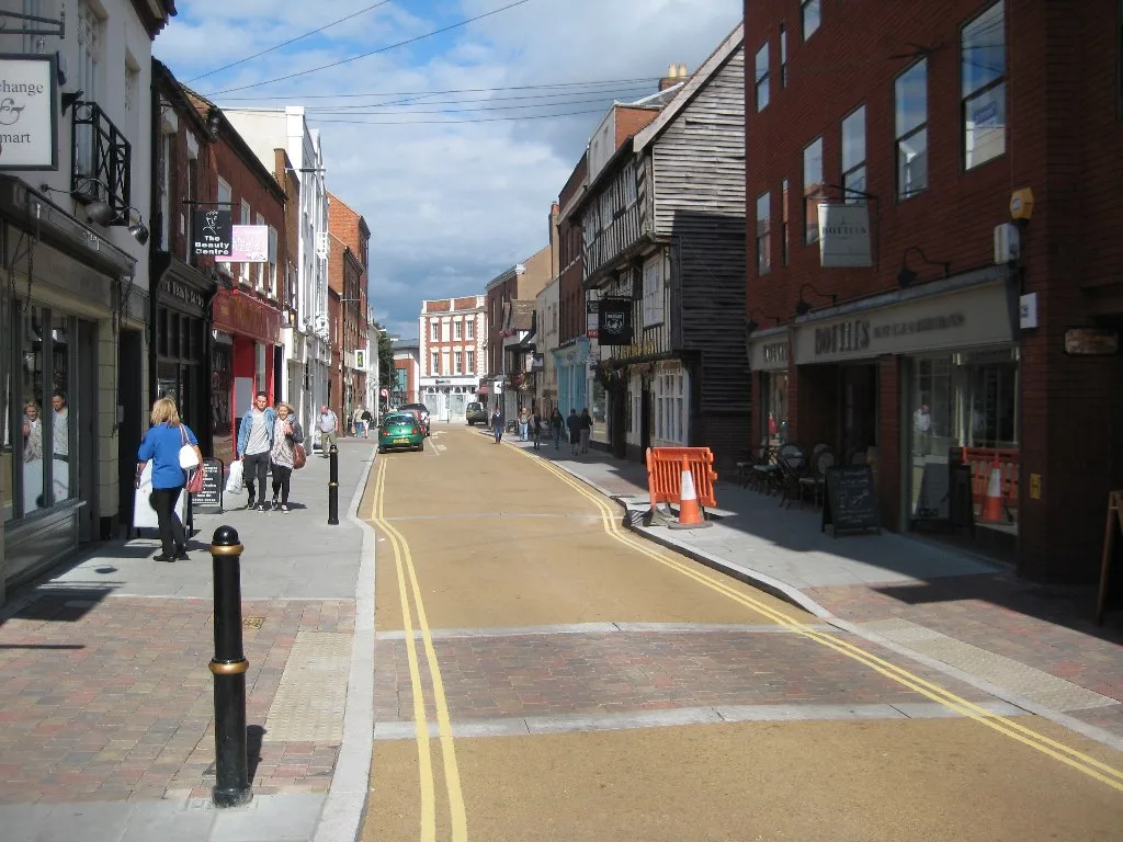
New Street, Charles Street and Edgar Street would lose cars under the council's 15-year plan. It prices 13 Worcester schemes at £88m, with no money attached.
Worcestershire County Council has published its plan for walking and cycling in Worcester, and it puts a price on the city centre for the first time. Thirteen costed schemes come to £88.06m in 2025 prices. The council expects them to take 10 to 15 years. None of them has any money attached.
The Worcester Local Cycling and Walking Infrastructure Plan was written for the council by the consultancy Jacobs and issued in its second version on 17 August 2026. It went live on the council’s website on 2 September, alongside plans for Droitwich Spa, Malvern and Pershore.
What it would do to streets you know
The single largest item is not a cycle route at all. It is the core walking zone, a £14.165m package covering the streets inside and around the city walls. Read line by line, it is the most concrete part of the document.
The plan would:
- convert New Street to a pedestrian prioritised street, with a ban on motor vehicles except for servicing
- do the same to Charles Street, and to Edgar Street, where a modal filter would stop cars entering from Sidbury
- extend the pedestrian zone to The Cross, St Swithin’s Street, Trinity Street, the Corn Market and The Shambles, with access kept for servicing
- make Lowesmoor one way eastbound for general traffic, diverting the rest via Pheasant Street and St Martin’s Gate, to free space for planting, seating and wider footways
- cut Bridge Street and North Parade from three traffic lanes to two, to widen the footway and open up the waterside
- explore stopping up Silver Street and removing the surface car park on the corner of the A38 to create a public square
- explore replacing the Cornmarket surface car park with green or open space
Several of those carry the same caveat in the document: the loss of carriageway space “will require modelling for feasibility”. None is a decision. Two of the car parks named are among the city centre spaces covered on our parking in Worcester page.
The thirteen schemes, and what each would cost
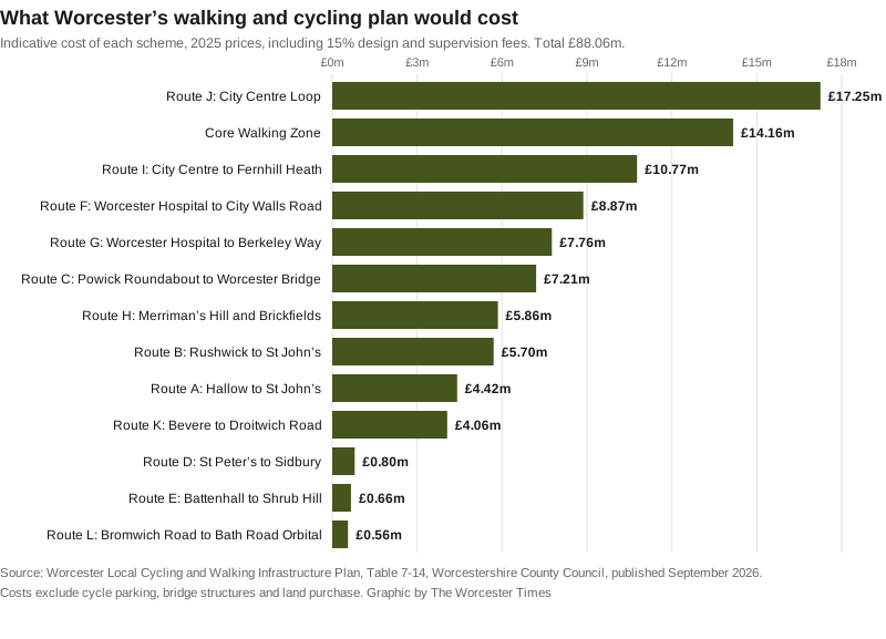
The council also ran each scheme through the Department for Transport’s appraisal tool to get a benefit cost ratio. On the department’s own scale, anything above 4 is very high value for money.
| Scheme | Cost | Benefit cost ratio | Priority |
|---|---|---|---|
| Route E, Battenhall to Shrub Hill | £660,000 | 5.59, very high | 1 |
| Route J, city centre loop | £17,250,000 | 4.60, very high | 2 |
| Core walking zone | £14,165,000 | 3.36, high | 2 |
| Route A, Hallow to St John's | £4,415,000 | 4.64, very high | 3 |
| Route D, St Peter's to Sidbury | £795,000 | 4.42, very high | 4 |
| Route F, Worcester Hospital to City Walls Road | £8,870,000 | 3.19, high | 5 |
| Route H, Merriman's Hill and Brickfields | £5,855,000 | 5.28, very high | 5 |
| Route I, city centre to Fernhill Heath | £10,770,000 | 2.63, high | 5 |
| Route G, Worcester Hospital to Berkeley Way | £7,760,000 | 3.14, high | 6 |
| Route L, Bromwich Road to Bath Road orbital | £555,000 | 5.37, very high | 7 |
| Route C, Powick Roundabout to Worcester Bridge | £7,205,000 | 2.81, high | 8 |
| Route K, Bevere to Droitwich Road | £4,060,000 | 1.74, medium | 8 |
| Route B, Rushwick to St John's | £5,700,000 | 2.21, high | 10 |
Priority is the plan’s own ranking, with routes tied where their scores tie. Four further routes, M, N, O and P, were upgraded to primary status after the public engagement and have not been costed or appraised yet.
The cheapest scheme is the one the plan ranks first. Route E, Battenhall to Shrub Hill, would cost £660,000 and returns £5.59 of benefit for every pound. It is 3.81km long and it is mostly not construction at all. It is a 20mph limit, signage, and quieter neighbourhood treatments on Rose Bank, Albert Road, Wyld’s Lane, Midland Road, Park Street, Foundry Street and Carden Street. The only substantial build is widening the off-road path between the A4440 and Battenhall Road, and a new cycle crossing of London Road at Camp Hill Road.
At the other end, the city centre loop would cost £17.25m on its own. That is nearly a fifth of the whole plan for 9.46km of route.
The money is the problem
The council says so itself. “While LCWIPs do not come with direct funding, having an adopted plan puts the County Council and partners in a strong position to secure investment as new funding opportunities become available,” its announcement reads.
Councillor Tom Wells, the cabinet member for highways and transport, said the plans “set out a clear framework for how we can enhance walking and cycling routes” and focus on “improving safety, accessibility, and connectivity, making it easier for people of all ages and abilities to get around without always relying on the car”.
For scale, the £88.06m is spread across a decade and a half, and it excludes cycle parking, bridge structures and land purchase. The council’s own capital spending on highway maintenance was projected at £52.6m for a single year, 2025/26.
What changed after residents were asked
The plan follows a public engagement run in autumn 2025, which drew 541 responses plus written submissions from organisations including Bike Worcester. The council says most respondents agreed with the aims.
Eleven of the Worcester cycle routes were altered as a result, and one was added. Among the changes:
- Route E was moved onto Camp Hill and Rose Bank instead of using Wyld’s Lane
- Route A gained a link via Martley Road and Elgar Way to the urban extension
- Route C was extended into Powick, and route B through the Rushwick strategic growth area
- Route K gained a spur via Northwick Road
- a new route X was added, running from Shrub Hill across the railway to Railway Walk, Vicar Street, Rainbow Hill, Belmont Street, Barker Street and Gillam Street to Green Lane
No changes were made to the proposed walking network.
What it means for you
Nothing changes on the ground yet, and nothing will change without a separate funding bid and, for anything that removes traffic lanes or bans cars, a traffic order with its own consultation. Those are the notices that appear weekly in the statutory list, the same route the Sherriff Street and Laugherne Road parking proposals are going through now.
What the plan does do is set the order. If money arrives, the council has already said which schemes it would spend it on first, and Battenhall to Shrub Hill is at the top of that list because it is cheap rather than because it is ambitious. If you live on Rose Bank, Wyld’s Lane or Midland Road, a 20mph limit and a quieter neighbourhood scheme is the most likely thing to reach your street in the next five years.
If you want to read the detail for your own area, the full document runs to 84 pages and its route plans are drawn street by street. The engagement report published with it sets out what people asked for and what the council changed in response.
Sources
- Worcester Local Cycling and Walking Infrastructure Plan, Worcestershire County Council and Jacobs, version 2 issued 17 August 2026, for every scheme, intervention, cost and score. Table 7-14 gives the indicative costs, Table 7-15 the benefit cost ratios, Table 8-2 the prioritisation and Table 7-13 the core walking zone interventions.
- South Worcestershire LCWIPs, Worcestershire County Council, for the engagement response count and the summary of changes by route.
- County Council launches new South Worcestershire Local Cycling and Walking Infrastructure Plans, Worcestershire County Council, 2 September 2026, for the funding position and Councillor Wells’s comments.
- Worcestershire County Council, Local Highway Maintenance Transparency Report for the 2025/26 highway maintenance capital figure.
Have your say