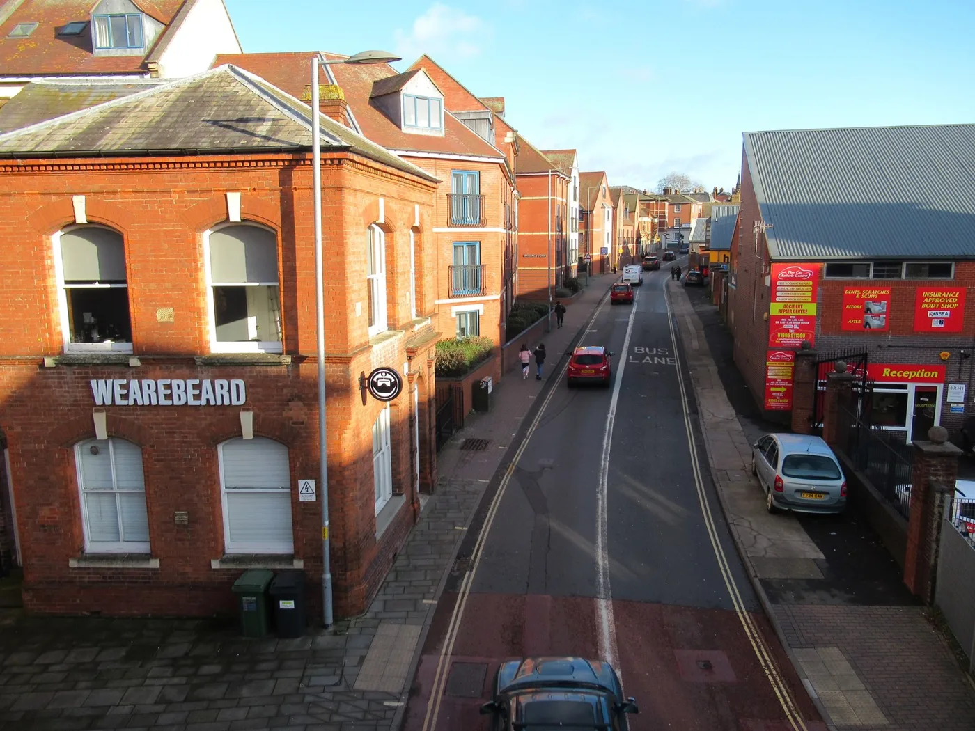
The Butts measured 41.8µg/m3 of nitrogen dioxide in 2025, the only Worcester site still over the legal limit at a home. The whole city is a management area.
One Worcester street is still breaking the legal limit for nitrogen dioxide, and it is the only one. A monitoring tube in The Butts recorded 41.8 micrograms per cubic metre as an annual average in 2025. The national objective is 40. (Worcester City Council, Annual Air Quality Update, report to Licensing and Environmental Health Committee, 7 September 2026)
The figure is falling. It was 43.9 in 2024, and the city’s own report puts the peak at 55.03 in 2016 and the low at 35.9 in 2020, the first lockdown year.
Councillors are asked only to note the report. They meet at 7pm on Monday 7 September at the Guildhall.
Why The Butts is the one that counts
Worcester measures nitrogen dioxide with 36 diffusion tubes. Several sit right at the kerb, so the readings are corrected back to the nearest place someone actually lives, usually a house front. That correction is what decides whether a limit has been broken.
Once it is applied, The Butts is the only monitoring point in the city left above 40.
The city’s average across all 36 tubes barely moved. It fell 0.41µg/m3, or 1.3%, from 31.02 in 2024 to 30.61 in 2025. Fourteen of the 36 sites recorded a fall.
Over five years the picture is more awkward than that sounds. Most sites are higher than they were in 2021, because 2020 and 2021 were pandemic years with far less traffic. The council says the long-term trend is still downward.
The whole city is an air quality management area
Worcester City Council declared an air quality management area covering its entire political boundary on 11 June 2019. Not a street, not a junction: the city.
Neighbouring districts have been going the other way. In 2025 Bromsgrove revoked its Kidderminster Road, Hagley area and its Lickey End and Redditch Road area. Wychavon revoked Worcester Road, Wychbold and Port Street, Evesham. (Worcestershire Regulatory Services, Air Quality Management Area Declarations)
Worcester’s statutory report says no amendment to its own area is proposed.
Two streets going in opposite directions
The Butts is improving. Astwood Road in Rainbow Hill is not.
Astwood Road produced the highest raw tube reading anywhere in the city in 2025, at 43.5µg/m3, and it has risen in every one of the last five years. It does not break the limit, because the tube sits 8.3 metres from the nearest home and the corrected figure is 31.0.
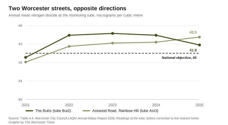
The five-year readings, in micrograms per cubic metre:
- The Butts (But2): 39.1, 43.9, 44.3, 43.9, 41.8
- Astwood Road (Ast3): 38.1, 41.5, 42.2, 42.4, 43.5
Both series run 2021 to 2025. (Table A.4, LAQM Annual Status Report 2026)
The report to councillors differs from the approved one
The statutory Annual Status Report was submitted to Defra on 30 June 2026 and approved on 31 July. The summary going to councillors on Monday does not match it on three points.
- Which site was highest. The committee report says the highest recorded concentration in the city was 41.8 at The Butts. The approved report says it was 43.5 at Astwood Road, and that Foregate Street also exceeded the objective at 40.7 before correction. Neither appears in the committee report.
- The 36µg/m3 threshold. The committee report says three further sites came out above 36 once corrected back to the nearest home. The approved report says they came out below 36. The council’s own published distance calculations give 33.9, 31.3 and 35.8. The direction matters: the report explains that 36 is the level technical guidance flags when considering whether a management area can be revoked.
- The city average. The committee report gives a fall of 0.41µg/m3 to 30.61. The approved report gives 0.48µg/m3 to 30.54.
The Annual Status Report is the statutory document, and it is the one Defra approved. The committee report is a summary of it, written by Worcestershire Regulatory Services on the council’s behalf. Councillors reading only the summary would not learn that Astwood Road recorded the city’s highest reading, or that Foregate Street exceeded the objective at all.
The fine particle numbers are better
Nitrogen dioxide is the problem in Worcester. Fine particles are not, on the evidence so far.
The city’s ten low-cost sensors averaged 7.53µg/m3 of PM2.5 in 2025. The legally binding national target is 10µg/m3 by December 2030, with an interim target of 12µg/m3 by December 2028. Worcester is already under both. Defra’s national background mapping put the city at 6.60µg/m3 for 2024, which is close enough to give the sensor figure some credibility. (Appendix 1, air quality targets)
Two cautions. Defra does not accept low-cost sensors for statutory reporting, because they are not accurate enough. And a proper reference-standard monitor has only been running in the Tolladine area since April 2025, as part of the national network, so there is no year-on-year comparison yet.
The sensors have a funding cliff in January
The maintenance contract for every one of Worcester’s low-cost sensors expires on 12 January 2027. The report says officers are “exploring options, costs and available funding” to extend it. Nothing is secured.
The live readings are public in the meantime. The portal took 1,600 visits from 430 users in the year to June 2026.
What it means for you
- You can check your own street now. The real-time network is at portal.earthsense.co.uk/WorcestershirePublic, free and without an account.
- Living in the management area does not mean your road is over the limit. The designation covers the whole city. On the 2025 data, one monitoring point is.
- The worst readings follow the traffic. The council says narrow streets with tall buildings trap the fumes. The corridors it names are The Butts, All Saints Road and Bridge Street; the Tything to Foregate Street; Lowesmoor, Rainbow Hill and Astwood Road; St John’s Bull Ring; and London Road.
- You can speak on it on Monday. The committee allows fifteen minutes in total for public representations, five minutes each, on anything on the agenda. It sits at 7pm on 7 September at the Guildhall.
- The council’s air quality survey has closed. It ran on the Worcestershire Regulatory Services website and shut on 1 September, so there is nothing left to fill in.
More Worcester information: roadworks and travel, parking in Worcester and planning news.
Have your say
We read every message. To comment on this story, email the newsdesk and we may publish a selection of responses: hello@worcestertimes.co.uk.