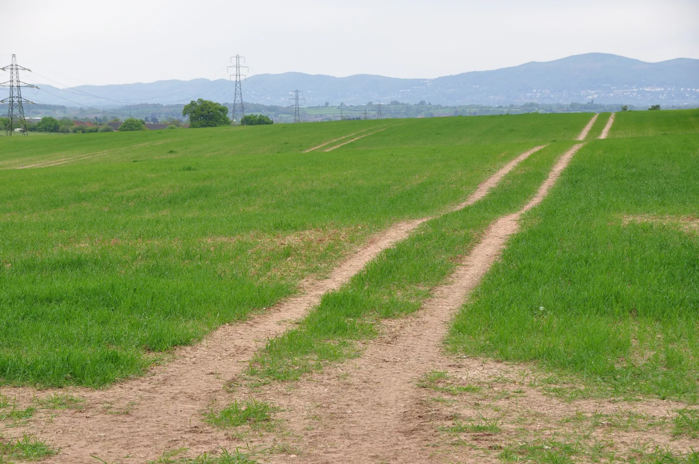

The same 5.05 hectare field off Whittington Road was screened for up to 180 homes in June, then for a supermarket, a care home and 70 homes in August.
A developer has twice asked Worcester City Council to rule on the same field at Battenhall Farm, and the two schemes it described are not the same thing at all.
In May it was housing. By July it was a supermarket.
The Battenhall Farm land is about 5.05 hectares off Whittington Road, roughly 2.5km south-east of Worcester city centre. New College Worcester sits to the north-east of it and Whittington Hall business park lies beyond the trees on its south-eastern boundary. No planning application has been submitted for it. What has happened is two requests for a screening opinion, the formal step that decides whether a future application must be supported by a full Environmental Impact Assessment.
Both were made by Boningale Developments Limited through the planning agent Marrons, and both were decided by the council without going near a committee.
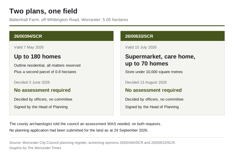
The two requests set out:
- 26/00394/SCR, valid on 7 May, for an outline residential scheme. The council’s notice records it as more than 150 dwellings, “up to 180”, on the 5.05 hectare parcel. A second parcel of about 0.8 hectares, bounded by a pair of houses to the north and the railway to the west, was also proposed for housing.
- 26/00633/SCR, valid on 15 July, for a mixed-use scheme on the same 5.05 hectares: a supermarket, a care home and up to 70 dwellings, with landscaping, open space and an access point. The council’s notice puts the supermarket at less than 10,000 square metres of floorspace.
The agent’s letter for the second request describes the identical parcel, southwest of Whittington Road with the business park on its south-eastern boundary. The council’s register, though, files it under a different address: Land at Middle Battenhall Farm, Upper Battenhall. Anyone searching the register for one will not necessarily find the other.
What the council decided
The same answer, twice: an Environmental Impact Assessment is not required.
Duncan Rudge, the council’s Head of Planning and Economic Development, signed the first screening opinion on 3 June and the second on 13 August. Both conclude that the impacts would be “localised in extent and capable of being satisfactorily considered through the submission of the validation requirements for a major planning application”.
Both notices also record that the site sits near a scheduled monument, described in the council’s own wording as a “Moated monastic grange and fishpond” (List Entry Number 1017310), and that development would affect the setting of that monument and the “visual connectivity with a National Landscape (the Malvern Hills)”. The council’s view is that neither effect is significant in the specific sense the regulations use.
The county archaeologist disagreed. Twice.
Aidan Smyth, responding for archaeology, told the council on 10 May that the site “retains a high archaeological potential meaning the site does require an environmental impact assessment”.
His response sets out what several years of fieldwalking there has turned up:
- Mesolithic flint cores, which he calls a rare find and the earliest human activity in the area
- Roman pottery
- a wealth of oyster shells
- large concentrations of early porcelain, likely from the Worcester factory
He also records a cropmark within the site marking the boundary of a post-medieval deer park “imparked by Queen Elizabeth 1st”. The park pale, he writes, is marked by “a significant and well loved tree which frames the Malvern Hills”, a view “often remarked as the last open space in the city from which the Malvern’s can be clearly enjoyed”.
When the second, mixed-use version arrived he was blunter. On 20 July he wrote that the scheme “most certainly has environmental impacts regarding cultural heritage” and that “the applicant has failed to identify that the site itself is with a Medieval Deer park which was later emparked by Queen Elizabeth Ist with a pale passing directly through the site”.
He asked for a desk-based assessment informed by multi-spectral analysis and a magnetometry survey, with trench evaluation before any application is determined.
What the other consultees said
Worcester Civic Society’s planning panel also told the council an Environmental Statement was required, on landscape grounds. Its response says the site is designated Open Space in the adopted local plan and sits next to a designated Significant Gap, and that with no concept masterplan submitted, “it is considered significant landscape effects are likely”. It asked for education to be scoped in as well.
The county council’s ecology adviser did not think an assessment was needed, but said the applicant’s claim that there were “no ecological constraints that cannot be mitigated” was “not fully evidenced at this moment in time”. No preliminary ecological appraisal, desk study, protected species assessment, biodiversity net gain baseline or lighting assessment had been submitted. Green Meadow, a Grassland Inventory Site noted as an MG5 meadow, lies immediately next to the land. The adviser also noted that the submitted drawings show a proposed country park immediately to the west, and that it was not clear whether it would form part of the application.
The county’s school place planners looked at the 70-home version and set out what it would generate in the Worcester South planning area:
- 16 full-time early years places
- 24 mainstream primary places, four per year group
- 16 mainstream secondary and sixth form places, three per year group
- three SEND places, two primary and one secondary
The catchment schools are Red Hill CE Primary and Nunnery Wood High. As of 27 July, the advice says, there were “insufficient places within the wards of St Peter’s Parish and Battenhall in Early Years settings”, and the secondary schools are “nearing or at capacity in all year groups”. A section 106 contribution towards education would be necessary, the county says, for the development to be sustainable.
Worcestershire Regulatory Services raised no objection on contaminated land, but asked that pesticide and herbicide contamination be considered in any preliminary risk assessment given the land’s agricultural history, and flagged a substation, a small pond and a sewage tank nearby. It also wants to approve the methodology for the air quality assessment before it is done.
The county highway authority made no comment on the assessment question. It did disclose one thing: a highways pre-application advice request for the development is already with it, so the conversation about a transport assessment has started.
The policy the field sits under
The South Worcestershire Development Plan Review was adopted on 26 March 2026 and runs to 2041. Two of its policies are relevant here.
Policy SWDPR 08 lists eight Significant Gaps, designated “to retain the separate identity of settlements and prevent coalescence”. Number six is “Whittington, south of Whittington Road” and a second area bounded by the A4440, Church Lane, Berkley Close, the M5 and Brewers Lane. The policy then says land within those gaps “will be kept open and essentially free of development”.
Policy SWDPR 48 covers Open Space. It says development of it “will not be supported other than in the circumstances set out in the NPPF”.
Neither Battenhall Farm nor a Whittington Road site appears as a housing or employment allocation anywhere in the 317-page adopted plan, which The Worcester Times checked in full on 24 September. The land is not one the councils have planned to build on.
What a screening opinion does, and does not do
It is worth being precise about what has and has not happened.
A screening opinion answers one question: does a future planning application have to come with a formal Environmental Statement? “EIA not required” means the council has decided it does not. It is not permission, it is not support for the scheme, and it does not stop the council refusing an application later on landscape, heritage, highway or policy grounds.
What it does do is remove a layer of documentation that would otherwise have to be produced, consulted on and published before any decision.
What it means for you
There is nothing to comment on yet. A screening opinion is not consulted on publicly, and as of 24 September no planning application had been registered for the site. We checked the council’s register for both Battenhall Farm and Whittington Road and found only the two screening requests.
If an outline application is submitted it will be a major application, which means a statutory consultation period, site notices and a published officer report. Whether it is decided by the Planning Committee or by officers under delegated powers is a separate question, and one that changed in Worcester this year. We set out the new rules in our report on the council’s planning delegation vote.
Practical things you can do now:
- Track the two references on the council’s register: 26/00394/SCR and 26/00633/SCR. Each register page has a “Track This App” option that emails you when anything changes.
- Watch for a new reference at the same address. We will be doing the same, and will report it when it lands.
- If you want to see what the council is currently deciding elsewhere in the city, our Worcester planning news page is updated as decisions are published.
Sources
Every figure above comes from the council’s own planning register and the documents filed on it.
- Screening opinion 26/00394/SCR, Worcester City Council, decided 4 June 2026, including the agent’s screening letter, the decision notice and the consultee responses quoted here.
- Screening opinion 26/00633/SCR, Worcester City Council, decided 13 August 2026, including the re-screening letter, the decision notice and the county education advice of 27 July 2026.
- South Worcestershire Development Plan Review, adopted 26 March 2026, for policies SWDPR 08 and SWDPR 48.
Have your say